
On March 8, 2026, an anonymous user on X posted something unusual, 31°40’59.89″N, 34°59’38.79″E , the exact GPS coordinates of a major Israeli communications facility. The post was a reply in a thread about the Iran-Israel war, essentially suggesting that Iran or Hezbollah should hit this site. The original thread was about Iran’s own satellite facility being destroyed by Israeli and US strikes. The post was essentially saying: here’s where Israel’s equivalent is, go hit it.

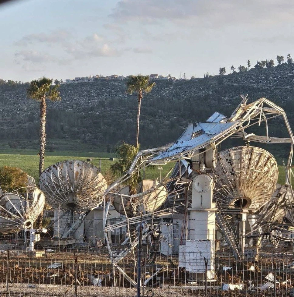
Twenty-four hours later, Hezbollah fired a barrage of what the IDF called “sophisticated missiles” at that exact location. Missiles struck the SES Ha’Ela Satellite Teleport in Israel’s Ha’Ela Valley. Multiple satellite dishes were damaged. The IDF confirmed the attack.
Nobody has proven the tweet caused the strike. But the timing is hard to ignore and the bigger point stands regardless: in today’s wars, a social media post can potentially do what a spy once took months to accomplish.

What is ASAT
ASAT stands for Anti-Satellite, any weapon or action designed to disable or destroy a satellite or its supporting systems.
Most people imagine ASAT as firing a missile into space to blow up a satellite. That does exist India demonstrated it in 2019 with Mission Shakti, as did China in 2007. But it is complicated, expensive, and creates dangerous debris fields in orbit.
The smarter and far more common approach is to simply destroy the ground station the dish antennas and control facilities on Earth that the satellite depends on. No ground station means the satellite above becomes essentially useless for military purposes, even if it remains physically intact in orbit. That is precisely what the attack on Ha’Ela was a ground-based ASAT strike. No rockets into space required. Just a missile hitting an antenna farm in a valley.
What the Satellite Facilities and Why Did They Matter?
Iran’s side – the ASAT programme: Iran had been quietly building a space programme with military teeth. One key project was the Chamran-1 satellite, launched in 2024 and developed by Iran’s defence ministry. More worrying to Israel was what came with it — a facility in Tehran that was developing technology to attack satellites in space. This is called an ASAT capability (more on that below).
On March 16, 2026, Israel announced it had destroyed that facility in central Tehran. The goal was simple: Iran was building the ability to blind Israel’s satellites, so Israel eliminated that ability before it became operational.
Israel’s side — the Ha’Ela Teleport: The SES Ha’Ela Satellite Teleport is not a dramatic-looking military base. It is a large field of over a hundred satellite dish antennas in a valley south of Jerusalem. But it is one of Israel’s most important communications nodes — the place where signals travel between the ground and satellites in orbit.
Think of it as the internet router for Israel’s satellite network. Destroy the router and the satellites above become far less useful. For a country at war, that matters enormously — satellite links carry intelligence data, military communications, and targeting information in real time.

What This Means for the Future of War and What India Should Learn
The Ha’Ela incident is a warning about something bigger: the line between public information and military targeting intelligence has almost disappeared.
During the Russia-Ukraine war, civilians used Google Maps, flight tracking apps, and social media posts to spot Russian military columns. Some of that open-source intelligence fed directly into Ukrainian strike decisions. Now, in the Iran-Israel conflict we may be seeing it happen even faster, coordinates shared on X, a strike within twenty-four hours.
This has a name: OSINT, or Open-Source Intelligence. What has changed is the speed. And that speed leaves almost no time to react.
India learned some of this the hard way during Operation Sindoor.
In May 2025, India launched precision missile strikes against terrorist infrastructure in Pakistan — the most significant Indian military action since 1971. BrahMos missiles hit targets deep inside Pakistani territory. India’s air defence systems intercepted Pakistani drone retaliatory attacks. By any measure it was a military success. But analysts noted real gaps. Pakistan and Turkey ran an aggressive disinformation campaign i.e. fake videos, fabricated casualty numbers, bot networks that India struggled to counter in real time.
And here is the direct connection to Ha’Ela: India’s own satellite ground stations and communications infrastructure are publicly mapped, commercially documented, and visible in satellite imagery available to anyone. If an adversary wanted to build a targeting list using only open-source data, they could. The question is whether India’s doctrine and defences are ready for that reality.
The lessons are straightforward: Satellite ground stations need to be treated as frontline military assets, not just infrastructure. India’s counter-intelligence needs to actively monitor when its facilities are being mapped or discussed on open platforms. And the country needs redundant, dispersed satellite communications so that losing one node does not cripple the network.
Conclusion
India, in all their future conflicts must also factor in the forces working inside the country along with the external foes as the future of warfare will be unprecedented and countries may find themselves unprepared for the possible circumstances.
Whether or not that tweet guided Hezbollah’s missiles is almost beside the point. The point is that a random anonymous post contained enough precise information to potentially direct a missile strike at a critical military communications facility and nobody stopped it.
Wars are no longer fought only on physical battlefields. They are fought in orbit, on social media, and through information often before the first shot is fired.

An interesting article. This brings to the fore the need for having spaced out earth station redundancies. Israel may not have the landmass to do so. India certainly has these redundancies.
Thanks Sir for your Valuable comments
Brilliant !! Shows how OSINT has been weaponised.
I would like to add here that for us in India, the SES Ha’Ela case is a warning that future wars will be fought not only with missiles and drones but also with metadata: every photo, every tweet (containing specifics) and every open‑source map becomes a potential targeting vector. Guarding against this means treating social media and OSINT as part of national defence architecture, not just as a PR or propaganda tool.
Future wars will see more use of social media, geotagged posts, live videos, drone‑shots, and even mining of corporate‑websites to build 3D maps, entry‑points, and weak‑side profiles.
The core lesson is: protect not just hardware, but also information bleed‑out—especially where photos, maps, and posts can turn into enemy targeting data. We need to regulate ie, create a law AND enforce ruthlessly where blurring of GPS metadata for all essential infra is done across the board … we must encourage only “generic” imagery and remove/blur exact layouts, build OSINT‑awareness amongst ourselves, military and civil alike. Set up dedicated OSINT units to track enemy‑side X/Twitter, Telegram, and all other SM platforms. Yes, easier said than done; but this is the need of the hour …. We must use AI‑driven tools to flag posts with coordinates, 3D‑model references, or repeated photography of the same facility, etc.
Time has arrived for us in India to conduct systematic OSINT/SOCMINT monitoring of recursive‑proxy fronts, bot‑networks, and hashtag‑hijacking, while integrating legal and technical counter‑narrative tools, sooner the better, and this time let’s not entangle ourselves into narrow silos of Babudom; Union List, State List, Concurrent List, MHA, MOD, military, civil, intelligence, my turf – your turf. Enough.
Thanks Sir for your valuable comments, which could actually act as an eye-opener for all
Wherever there is a large unstructured data as in Social Media, AI provides key inputs for conducting intelligence operations. Anthropic was used in Venezuela operations exactly for this purpose. India needs to find a trusted AI model to reduce our OODA loop.
Thanks Sir for your valuable comments & Good Wishes
Thanks Sir for your valuable comments & Blessings